
You can click the "Full-size map" link to see or save a large 1952 x 824 pixel PNG image or click the "Download game" to download the saved game in ZIP format (approx 30 KB).
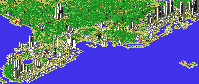
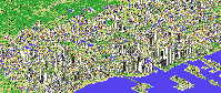
The theme of this layout is the classic New York to Florida passenger train fleets of the 1950's and early 60's, depicting the routes of the Atlantic Coast Line and Seaboard Air Line Railroads, along with their partners Florida East Coast Railway, Richmond Fredericksburg & Potomac and the Pennsylvania Railroad. The centerpiece of the system is the complex of tracks in and out of Jacksonville Union Terminal, the gateway to Florida.
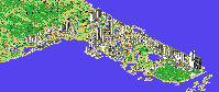
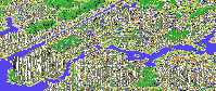
Who says you can't have two A-Train lines cross each other? This is a simulation of the contemporary railroad scene in South Florida, including Dade (left), Broward (center) and Palm Beach (right) Counties. The trains running on each route are color-coded. Rail operations include Tri-Rail, AMTRAK, Metrorail, CSX and Florida East Coast Railway. The southernmost station is Metrorail's Dadeland South. The F.E.C. and CSX mainlines continue off the map north from West Palm Beach and Mangonia Park. Lots of action!
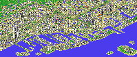
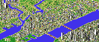
This layout models three rail systems operating in the Miami and Ft. Lauderdale area. Some "liberties" are taken with history. Closest to the ocean is the FLORIDA EAST COAST RAILWAY. Stations (from north to south) are Fort Lauderdale, Hollywood, North Miami and Miami. Further west is the SEABOARD AIR LINE RAILROAD. Stations are Fort Lauderdale, Hollywood, Opa-Locka and Miami Airport. METRORAIL is the single-track line from Hialeah (near Miami Airport) to the Brickell area just south of downtown Miami. If you look out in the ocean east of Port Everglades you will find Nassau and the Bahamas.
This layout models a statewide rail system in Florida with three long routes all connecting in Mouseland. Miami - St.Petersburg and Miami - Sarasota via Fort Lauderdale, West Palm Beach, Cocoa/Melbourne, Orlando and Tampa. Also Jacksonville - Pensacola via Daytona Beach, Orlando, Gainesville, Tallahassee and Panama City.
This layout models the Miami Metrorail system. All 21 stations are included! Trains run the double track route as frequently as I could schedule them without head-on collisions at the 2 terminals. From north to south, the stations are: Okeechobee (northern terminal), Hialeah, Tri-Rail/Metrorail Transfer, Northside (turn south), Dr.Martin Luther King, Jr., Brownsville, Earlington Heights, Allapattah, Santa Clara, Civic Center (cluster of tall buildings), Culmer, Overtown/Arena (downtown), Government Center (main downtown station, tallest buildings), Brickell (office towers south of the bridge over Miami River), Vizcaya (begin following US 1 south to Dadeland), Coconut Grove, Douglas Road, University (of Miami), South Miami, Dadeland North, Dadeland South (southern terminal).
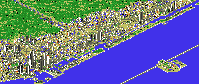
This simulation started as MANHTN.A-T by Peter Wilkens, which I downloaded from the Compuslurp railroad forum. The Empire State Building and World Trade Center are his, along with most of the geography. It inspired me to add some of the major subway lines and of course that meant I HAD to include the "real" A-TRAIN! You will recognize Manhattan instantly, New Jersey across the Hudson River, Queens across the East River and Brooklyn to south (across Newtown Creek), with the Bronx to the north.
This layout models the route system of the Port Authority Trans Hudson (better known as "PATH") in New York & New Jersey. The trains running on each route are color-coded and each equipment set has a train registry number. Very tricky crossovers were required to simulate PATH's two three-way junctions. All stations are represented - Newark, Harrison, Journal Sq, Grove St, Exchange Pl., World Trade Ctr, Pavonia Ave, Hoboken, Christopher St, 9th St, 14th St, 23rd St. & 33rd St.